Driving the Great Ocean Road
Direction, distances, fuel, EV charging, road conditions, caravan tips and mobile reception — everything you need to actually drive this 243 km of road.
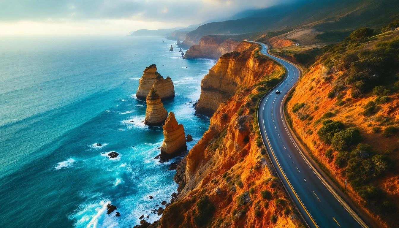
Drive west — three reasons
Of all the practical decisions involved in driving the Great Ocean Road, direction matters most. Drive west — Torquay to Warrnambool — for three reasons:
The lookouts are on the ocean side. Almost every pull-off, viewpoint, and beach access on the Great Ocean Road sits on the south side of the road. Driving westbound puts your car on the same side as those pull-offs, so you can pull in safely without crossing oncoming traffic. East-bound, you'd be making constant right turns across the highway — slower and less safe.
You arrive at the Twelve Apostles in late afternoon. The stacks face roughly south-west, so the seaward face — the one you photograph — lights up amber from late afternoon into sunset. Reach them earlier in the day and the light is flat or back-lit. Driving westbound naturally puts you there in the right window.
The road's most dramatic stretches come last. Driving west, the road builds — Surf Coast establishes the journey, the cliff section south of Lorne starts feeling adventurous, the Otway forest feels remote, the Shipwreck Coast at sunset is the climax. Drive east-bound and the trip peaks in the first hour and decompresses through forgettable Surf Coast suburbs.
The east-bound exception is sunrise photography at the Twelve Apostles — first light hits from the east. If you're doing a sunrise-focused trip, base in Port Campbell, drive east as a day loop, and stay flexible on the rest.
Fuel stops along the route
- Torquay — multiple stations, lowest prices on the road. Fill up here.
- Anglesea — single station, slightly higher prices.
- Aireys Inlet — small station, premium prices.
- Lorne — single station on Mountjoy.
- Apollo Bay — multiple stations, mid-range prices. Top up before driving west.
- Lavers Hill — only fuel option between Apollo Bay and Port Campbell. Higher prices.
- Port Campbell — single United station.
- Warrnambool — multiple stations, regional prices.
Strategy: fill at Torquay, top up at Apollo Bay, fill again at Warrnambool if continuing west.
Where to charge an EV
- Lorne Tesla Supercharger — 8 stalls at the foreshore. The best fast DC option on the road.
- Tesla Destination Chargers — Mantra Lorne, RACV Torquay, multiple Apollo Bay properties.
- Chargefox AC chargers — Torquay, Lorne, Apollo Bay foreshore, Port Campbell.
- Closest fast DC east — Geelong (multiple options including Tesla Supercharger).
- Closest fast DC west — Warrnambool (multiple options).
- Otway/Shipwreck Coast — sparse charging. Top up at Lorne or Apollo Bay before this leg.
Strategy: Tesla Supercharger at Lorne for fast DC; AC top-ups at hotel destination chargers overnight.
What to expect from each section
The 243 km road has three distinct character zones, each with different driving challenges:
Zone 1: Surf Coast (Torquay → Lorne). 45 km, ~50 minutes. Wide, well-maintained two-lane highway with gentle bends. Multiple towns provide regular fuel and amenity stops. Easy driving for any vehicle including caravans. The most car-friendly section of the road.
Zone 2: The cliff section (Lorne → Apollo Bay). 45 km, ~60 minutes signed but typically slower. Narrow, winding, with tight bends and steep drops on the ocean side. Signed at 80 km/h but most drivers average 50–60. Caravans and large motorhomes need to use slow-vehicle pull-offs. Watch for motorcyclists in the bends and timber trucks early in the morning. The most scenic but slowest section.
Zone 3: The Otway loop (Apollo Bay → Princetown). 60 km, ~75 minutes. Inland through dense temperate rainforest and rolling Otway hills. Two-lane sealed road with fewer bends than Zone 2 but limited overtaking. Lavers Hill is the only fuel option mid-zone.
Zone 4: The Shipwreck Coast (Princetown → Warrnambool). 80 km, ~90 minutes. Open coastal driving with multiple short detours to limestone formations. Wider road, easier driving than Zone 2, but more frequent stops. Watch for sudden vehicles entering and exiting attraction car parks.
Practical realities
Mobile reception is patchy. Telstra works best but drops out in the deeper Otway sections (Maits Rest, Cape Otway road, Hopetoun Falls area). Optus is patchier. Vodafone is the worst. Download offline maps before driving in.
Wildlife strikes are real. Eastern grey kangaroos move at dawn and dusk; koalas occasionally cross the road in the Otway sections. Drive at the speed limit, watch shoulders carefully at low light. If you hit an animal, call Wildlife Victoria (1300 094 535).
Weather closures happen occasionally. Heavy storms can close sections of the cliff road; bushfire warnings can close sections in summer. Check VicRoads or the VicEmergency app before driving in poor weather.
Caravans and motorhomes can drive the entire road but should keep to the speed limit, use slow-vehicle pull-offs, and avoid the cliff section during peak hour. Pacific Coast Touring Routes recommends caravans tow no more than 25-foot total length on this road.
Motorcycles love the cliff section. Watch for sudden lane shifts in the bends. The road has no dedicated motorcycle parking but most car parks accommodate bikes.
Bicycles can ride the road but expect significant traffic. Best ridden during off-peak weekdays in shoulder seasons. Multiple cycling tour operators run guided trips.
Driving FAQs
- What direction should you drive the Great Ocean Road?
- Drive west — Torquay to Warrnambool. The lookouts and pull-offs are mostly on the ocean side of the road, so westbound puts your car on the same side and you can pull in safely. You'll also reach the Twelve Apostles in late afternoon, which is the strongest light of the day. East-bound has you making constant right turns across traffic and arriving at the Apostles in mid-morning back-light.
- How long does it take to drive the Great Ocean Road?
- 243 km from Torquay to Allansford takes about 4.5 hours of pure driving without stops. With reasonable photo stops, plan 6–8 hours minimum. The cliff section between Lorne and Apollo Bay is the slowest part — signed at 80 km/h but you'll average 50–60 due to the bends. Most travellers take 2–3 days to drive the road properly.
- Are there fuel stations along the Great Ocean Road?
- Yes. Fuel is available at Torquay (multiple stations), Anglesea, Lorne, Apollo Bay (multiple stations), Lavers Hill, Port Campbell, and Warrnambool (multiple stations). Prices climb noticeably the further west you get. Fill up at Torquay before starting, top up at Apollo Bay, and you'll have no issues. Lavers Hill is the only fuel option between Apollo Bay and Port Campbell — top up there if you're driving the Otway loop.
- Are there EV charging stations on the Great Ocean Road?
- Yes, but coverage is uneven. Tesla Superchargers at Lorne (8 stalls). Tesla Destination Chargers at Mantra Lorne, RACV Torquay Resort, multiple Apollo Bay properties. Chargefox AC at Lorne foreshore, Torquay Surf Coast Plaza, Apollo Bay foreshore, Port Campbell visitor centre. The Otway and Shipwreck Coast sections have sparser coverage than the Surf Coast — top up at Lorne or Apollo Bay before driving west.
- Is the Great Ocean Road safe to drive?
- Yes, with appropriate care. The road is sealed throughout and well-maintained. The cliff section between Lorne and Apollo Bay has tight bends with steep drops — drive at the signed speed (80 km/h, often slower in practice), use the slow-vehicle pull-offs, watch for wildlife at dawn and dusk. The Princes Highway alternative is the safer choice for nervous drivers and in poor weather.
- Are there mobile reception black spots on the Great Ocean Road?
- Yes. Telstra has the best coverage but still drops out in the deeper Otway sections (Maits Rest, Cape Otway road, Hopetoun Falls area). Optus is patchier. Vodafone is the worst on this stretch. Don't rely on phone navigation — download offline maps before driving in. Major towns (Torquay, Anglesea, Lorne, Apollo Bay, Port Campbell, Warrnambool) all have good reception.
- Can you drive the Great Ocean Road in a caravan or motorhome?
- Yes. The road is engineered for all vehicles, including substantial caravans and motorhomes. The cliff section between Lorne and Apollo Bay is the trickiest — keep to the speed limit, use the slow-vehicle pull-offs liberally, and avoid driving in the morning when timber trucks operate. Multiple foreshore caravan parks accommodate large rigs. Avoid the inland Otway forest tracks unless your rig is designed for narrow roads.
- What are the road conditions like in winter?
- Generally fine. The road is sealed and maintained year-round. Occasional sections close after major storms or fires (mostly in summer fire season). Winter brings rain and reduced visibility on the cliff bends — drive with extra care. Ice is rare but possible at the higher Otway sections. Check VicRoads or VicEmergency before driving in poor weather. The Princes Highway alternative is more reliable in storms.