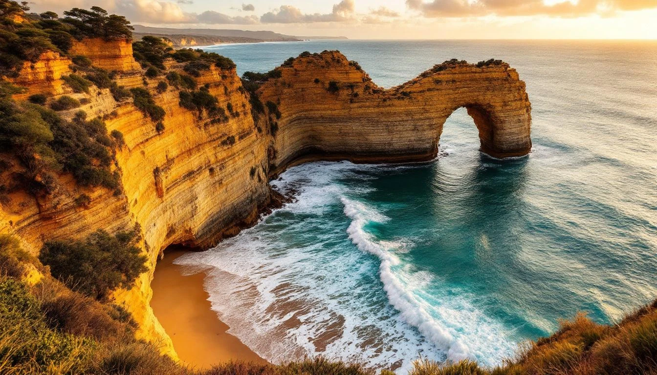
London Arch
The dramatic limestone formation that lost half its bridge on a calm afternoon in 1990 — and the rescue story that made international news.
The afternoon London Bridge collapsed
On 15 January 1990 — a warm summer afternoon, no storms, no warning — the inland span of London Bridge collapsed into the Southern Ocean. The bridge had been one of the Great Ocean Road's most-photographed formations: two natural arches connecting the mainland cliff to an offshore limestone tower, like a stretched stone version of London Bridge in England. The connecting span had stood for centuries.
That afternoon, two tourists — a man and woman — were standing on the offshore section of the bridge when the inland arch fell. They survived but found themselves on what was now an isolated rocky island, separated from the mainland by 100 metres of suddenly-impassable surf. Word spread back to Port Campbell, the Victorian Police Air Wing dispatched a helicopter, and the pair were winched off about an hour later. Both were unhurt and unusually composed in the press photographs taken on landing.
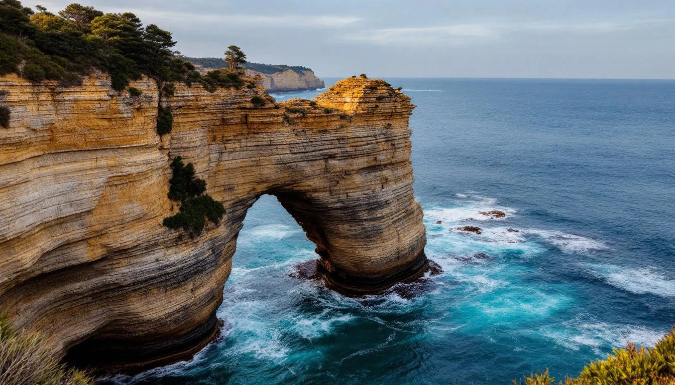
The collapse made international news. It also fundamentally changed how Parks Victoria assessed safety at the Shipwreck Coast formations. Today, the surviving arch — the seaward span — is what travellers come to see. The formation was renamed London Arch to reflect the loss of the bridge, and signage at the lookouts tells the collapse story in detail.
The reason the collapse matters beyond the human-interest drama is geological: it's a vivid demonstration of the same erosion process that creates and destroys every formation along the Shipwreck Coast. The Twelve Apostles are eroding at roughly two centimetres a year. New stacks are forming. Old ones are falling — a stack near the main Apostles lookout collapsed overnight in 2005. London Bridge's collapse was the most dramatic example, but it's not exceptional. The coastline you see today is a snapshot of a process that has never stopped.
Two viewing platforms, twenty minutes
The car park is on the inland side of the Great Ocean Road, signposted from both directions. From the car park, paved paths radiate out to two cliff-top viewing platforms — both step-free and accessible.
- Upper viewpoint — directly above the formation, looking down at the seaward arch with the gap from the collapsed inland span visible. The interpretation board here tells the 1990 story in detail. 5-minute walk from the car park.
- Lower (lateral) viewpoint — connected by a short paved path, this platform is set further back along the cliff for a side-on angle. Better for the "showing where the bridge used to be" composition.
Don't attempt to access the cliff edges outside the platforms. The whole limestone coast is actively eroding and the visible cracks aren't always the warning ones. The 1990 collapse demonstrated that established formations can fail without warning.
For most travellers, 30 minutes covers London Arch comfortably. Combine with The Grotto (4 km west, similar visit length) for a single 90-minute western Shipwreck Coast circuit before or after sunset at the Twelve Apostles.
The strongest angles
London Arch suits a slightly tighter framing than the wider Twelve Apostles compositions. The seaward arch is a single dramatic subject; let it be the focus.
- From the upper viewpoint — 35–50mm focal length captures the arch with enough surrounding sea for context. Late-afternoon side light is essential.
- From the lower (lateral) viewpoint — 70–100mm tightens onto the arch and shows the gap where the bridge stood. Strong storytelling composition.
- The visible collapse line — at the right angle, you can frame the standing arch with the visible erosion line on the cliff where the inland span used to attach. This is the photo that tells the 1990 story without words.
- Long exposure (1–4 seconds) — smooths the surf around the arch base. Use a polariser to cut glare and saturate the water. ND filter for daylight long exposure.
- Blue hour — 15 minutes after sunset. The limestone glows in residual warm light against a deep cobalt sky. Bring a tripod.
The western Shipwreck Coast circuit
London Arch is the entry to the western Shipwreck Coast cluster. Continue 4 km west for The Grotto, another 7 km for Bay of Islands.
The Grotto
4 km west. Stairway down to a sea-arch viewing platform that sits below sea level at high tide.
Bay of Islands
15 km west. Wide stretch of offshore sea stacks. The same erosion as the Apostles, often empty.
Twelve Apostles
20 km east. The signature stop. Time it for sunset, photograph blue hour after.
London Arch FAQs
- Why is London Arch called London Bridge?
- Until 15 January 1990, the formation consisted of two natural arches forming a bridge that connected the cliff to an offshore stack — visually similar to London Bridge in England. On that day, the inland arch collapsed without warning, leaving two tourists stranded on the offshore section (the rest of the bridge). They were eventually rescued by helicopter. After the collapse, the formation was renamed London Arch — referring only to the remaining seaward arch.
- What happened in the London Bridge collapse of 1990?
- On a calm afternoon in January 1990, the inland span of London Bridge collapsed into the sea without warning. Two tourists were on the offshore section at the time and were stranded as the bridge fell behind them. Both were unhurt but had to wait for a Police helicopter rescue. The collapse made international news and changed how Parks Victoria approaches risk assessment at all the Shipwreck Coast formations.
- Where is London Arch?
- London Arch is in Port Campbell National Park, about 8 kilometres west of Port Campbell town on the Great Ocean Road. There's a free signposted car park with paved paths to two viewing platforms. The formation sits about 200 metres offshore.
- Is London Arch worth visiting?
- Yes — and it's typically much quieter than the Twelve Apostles. The formation is dramatic, the historical context (the bridge collapse) gives it narrative weight, and the lookouts are usually empty in autumn and winter. Most travellers spend 30 minutes here. Combine with The Grotto (4 km further west) for a single 90-minute Shipwreck Coast western circuit.
- Can you walk on London Arch?
- No. The formation is offshore and there's no access. The two viewing platforms on the cliff give you the strongest possible angles. Don't attempt to climb fences or descend the cliff — the area is unstable, and the 1990 collapse demonstrated that even well-established formations can fail without warning.
- What's the best time to visit London Arch?
- Late afternoon for warm side-light on the limestone face. The formation faces roughly south-west, so it lights up similarly to the Twelve Apostles in the last 90 minutes before sunset. Sunrise also works for soft pink light, and London Arch has the advantage of being far less crowded than the Apostles at any time of day.
- How long do you spend at London Arch?
- Allow 30 minutes — 5 minutes from the car park to the upper viewpoint, 10 minutes between viewpoints, 10 minutes for photos. For dedicated photographers wanting blue-hour shots, 90 minutes lets you experience the colour change properly.
- Is London Arch wheelchair accessible?
- Yes — both viewpoints are connected to the car park by paved, step-free paths suitable for wheelchairs, prams, and travellers with mobility needs. The platforms have railings and benches.