The Memorial Arch
The wooden gateway at Eastern View where every Great Ocean Road trip officially begins — and the under-told story of who built the road, and why.
The world's largest war memorial doubles as a coastal road
Most travellers think of the Great Ocean Road as a tourist attraction. It is — but it was built as a war memorial first, and a road second. After WWI ended in 1918, the Australian government faced two simultaneous problems: returning servicemen needed work, and remote coastal communities along Victoria's south-west had no reliable land link to Geelong or Melbourne. The plan was to combine both: employ the returned men to build a coastal highway, and dedicate the road to the comrades they had lost.
Roughly 3,000 men worked on the road over thirteen years between 1919 and 1932. Tools were primitive — picks, shovels, wheelbarrows, occasional dynamite. Living conditions were rough; workers slept in canvas tents along the cliff edge, often in driving rain. The work was paid but slow: the survey alone took two years, and the most challenging section between Lorne and Apollo Bay required carving the road into sheer cliff face by hand.
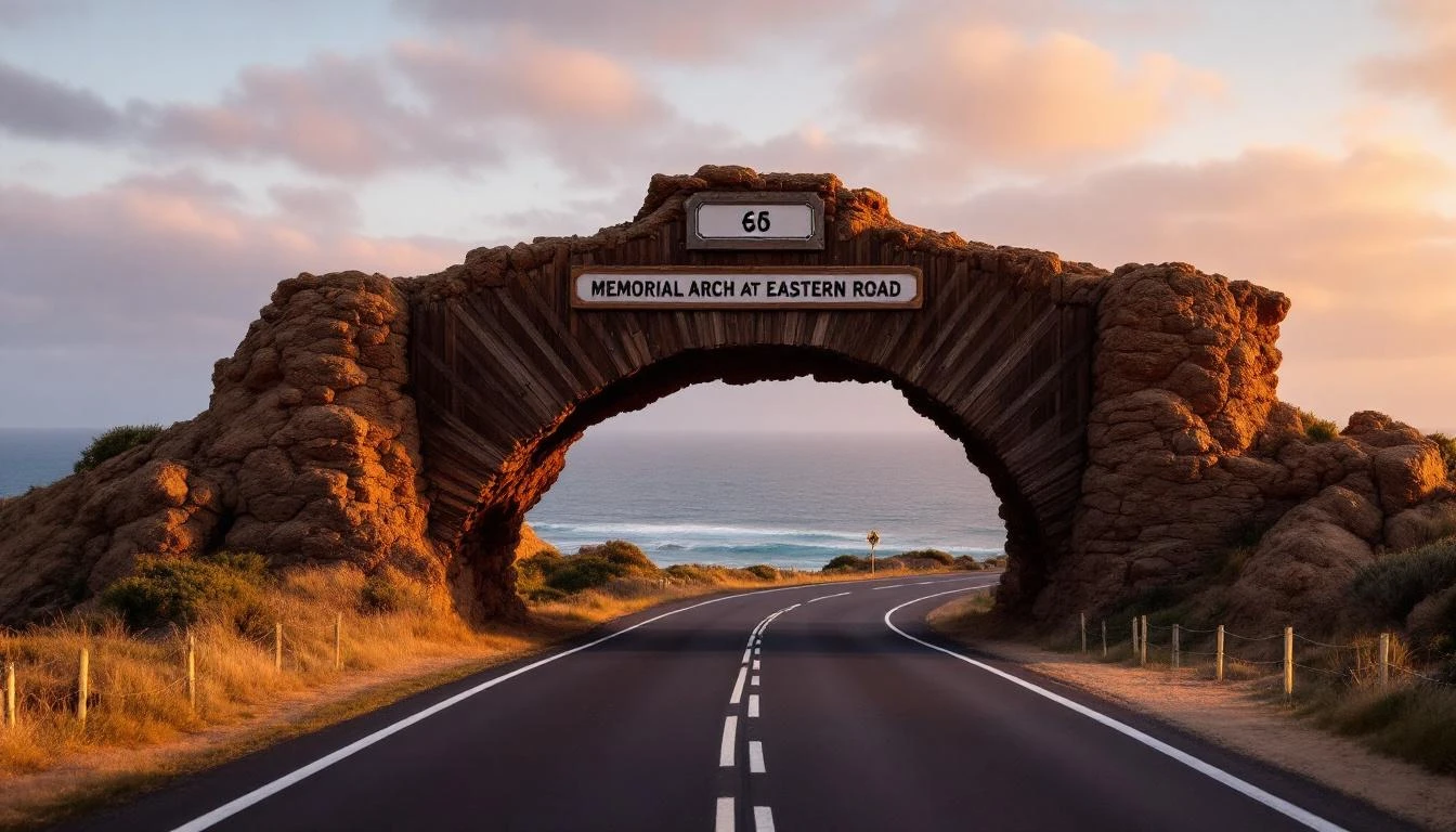
The Memorial Arch at Eastern View marks the symbolic start of that road. The plaque alongside reads, in part: "This Great Ocean Road, built by returned soldiers in memory of their comrades who paid the supreme sacrifice in the Great War." It's the only place on the entire route where the memorial purpose is made explicit. Read it before you drive on.
A short history of the arch itself
The arch you see today is the third structure on this site. The original was completed in 1939, seven years after the road itself opened, as a permanent dedication. That arch stood for forty-four years until the catastrophic Ash Wednesday bushfires of February 1983, which raced across the Otway Ranges and incinerated almost everything in their path along this stretch of coast.
The replacement arch was raised the same year and stood for nearly two decades before deterioration and a 2006 truck strike forced another rebuild. The current arch is essentially a faithful reconstruction of the 1939 design — heavy timber posts, a horizontal beam carrying the inscription, and the simple silhouette that has appeared in millions of road-trip photographs.
The strikes and fires haven't been the only test. In 2019, vandals scrawled graffiti across the arch's beam and Parks Victoria had to undertake a restoration. The local community rallies around the arch fast — it's not just a tourist site, it's regarded by many Victorians as a meaningful war memorial that happens to be on a tourist road.
Park, photograph, read, drive on
The arch sits at Eastern View on the Great Ocean Road, between Aireys Inlet and Lorne. Approaching from the east (Torquay direction), it appears around a bend with the ocean on your left — slow down before you reach it because the car park entry is immediately past the arch.
Park on the ocean-side pull-off. There's room for about 25 cars and a couple of coach bays. The car park has picnic tables, a memorial plaque, and a small interpretation board that's worth the two-minute read for the historical context. Toilets are not provided here — the closest are 4 km north in Aireys Inlet.
For photography, the strongest angle is from the car park looking back at the arch with the road sweeping under it. Get low — about waist height — to emphasise the road perspective. A 24mm to 35mm lens captures the full arch with the highway leading the eye through. Avoid midday; mid-afternoon to late-afternoon (3–5pm in summer, 2–4pm in winter) gives the warmest light on the timber.
Don't try to walk through the arch. The Great Ocean Road is a busy two-lane highway with no pedestrian crossing here, and visibility around the bend is poor in both directions. Stay in the car park; the photo from there is the better composition anyway.
What's nearby
The Memorial Arch is in the middle of the Surf Coast leg. Within 15 minutes' drive in either direction:
Aireys Inlet
4 km north. Coffee, the Split Point Lighthouse, the cliff-top walk, and a quieter alternative to Lorne.
Aireys Inlet guide →Split Point Lighthouse
5 km north. 1891 lighthouse on the Aireys headland — climb the tower, walk the path, find Round the Twist locations.
Lighthouse guide →Lorne
12 km south. Seaside resort town, the pier, Erskine Falls in the hills behind, and the best café strip on the road.
Lorne guide →Memorial Arch FAQs
- Where is the Memorial Arch?
- The Memorial Arch sits at Eastern View, between Aireys Inlet and Lorne, on the Great Ocean Road. The arch spans the highway and is signposted from both directions. There's a free car park immediately on the ocean side with picnic tables and the official memorial plaque.
- What does the Memorial Arch commemorate?
- The arch is a WWI memorial. It commemorates the approximately 3,000 returned servicemen who built the Great Ocean Road by hand between 1919 and 1932 as a tribute to their comrades killed in the war. The original arch was built in 1939; the current version is a 1973 replacement (the 1939 arch was destroyed in the 1983 Ash Wednesday bushfires) with subsequent restorations.
- Is the Great Ocean Road actually a war memorial?
- Yes — and it's the world's largest. The full 243 km of road is dedicated to Australian servicemen who died in WWI. Construction was funded partly by public donations and partly by tolls; the labour was done by returned soldiers using mostly hand tools. The memorial dimension is important historical context, not a marketing line.
- Is the Memorial Arch worth stopping at?
- Yes, but briefly — 10 to 15 minutes. The arch itself is a 60-second photo, the memorial plaque takes 2 minutes to read, and there's a small interpretation board on the road's history. Combine it with a coffee stop in Aireys Inlet (4 km north) or Lorne (12 km south).
- When is the best time to photograph the Memorial Arch?
- Late afternoon, with the sun behind you (looking west) lights the arch face warmly and avoids the harsh contrast of overhead sun on the dark wood. Sunrise also works but the arch is in shadow; you'd be shooting silhouette against the light. Avoid midday — the arch has heavy shadows that flatten the form.
- Can you walk through the Memorial Arch?
- The arch spans the highway itself, so you can drive through it but not safely walk through it — the Great Ocean Road is a busy two-lane highway with no pedestrian crossings here. Stay on the ocean-side car park and shoot from the pull-off; there's a clear, safe vantage that captures the full arch.
- Is there a second Memorial Arch?
- Yes — a smaller commemorative arch sits at the western end of the road near Allansford. It's lower-key and rarely photographed. The main Memorial Arch at Eastern View is the famous one and the de facto symbolic gateway to the road.
The arch is just the beginning
From here it's 230 kilometres of cliff bends, surf towns, koalas and limestone giants. Plan it properly with the 3-day classic.